28
JuneLandscape and Visual Impact Assessment (LVIA): Understanding How Development Changes Our Landscapes and Views
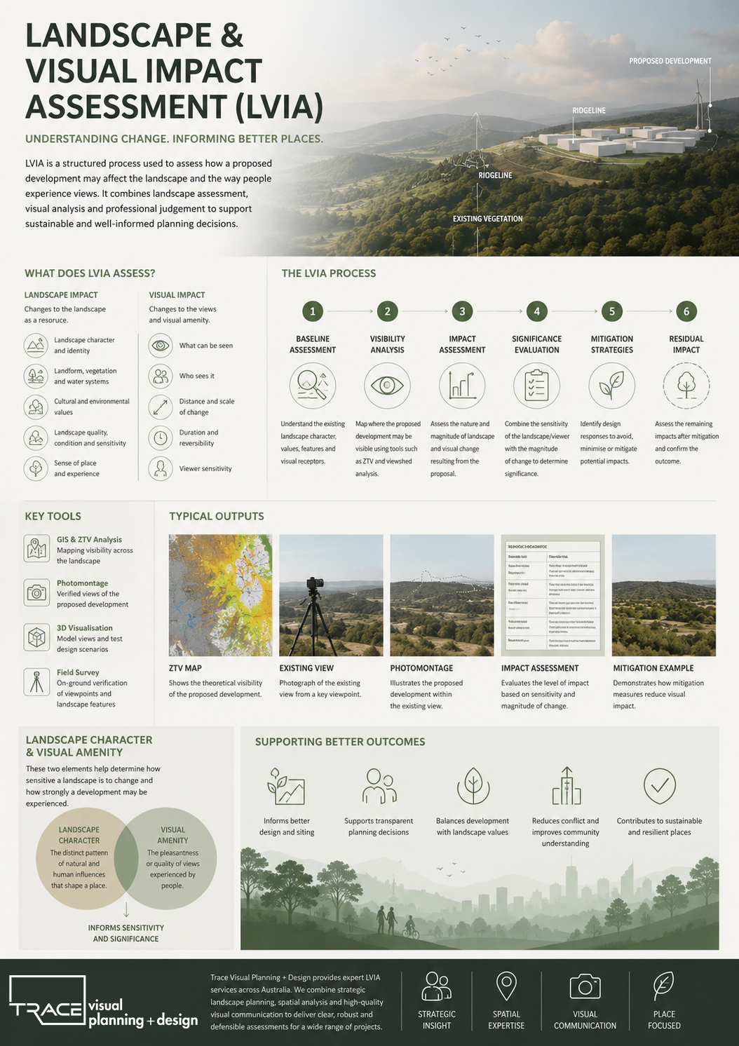
A Landscape and Visual Impact Assessment (LVIA) is a key component of planning and environmental assessment processes used to understand how proposed development projects will affect both the physical landscape and the way people experience views within that landscape.
LVIA is widely used across Australia for infrastructure, urban development, renewable energy projects, and major public realm works. It provides an evidence-based framework to assess change, guide design decisions, and support planning approvals.
For organisations such as Trace Visual Planning + Design, LVIA sits at the intersection of landscape planning, spatial analysis, and visual communication, ensuring that change to place is understood clearly, transparently, and early in the design process.
What is a Landscape and Visual Impact Assessment (LVIA)?
An LVIA is a structured assessment that examines two interconnected dimensions of impact:
1. Landscape impact
This refers to changes to the landscape as a resource. It considers how development affects:
- Landscape character (the distinct identity of a place)
- Landform, vegetation, and natural systems
- Cultural and environmental values
- Landscape quality, condition, and sensitivity
- Sense of place and landscape experience
2. Visual impact
This focuses on how development affects what people see. It evaluates:
- Changes in views and visual amenity
- Visibility of a proposed development
- Sensitivity of viewers (residents, commuters, visitors)
- Distance, scale, and duration of visual change
- Whether views are temporary or permanent
Together, these two components provide a comprehensive understanding of how development influences both place and perception.
Why LVIA is important in planning and development
LVIA is not only a technical requirement—it is a critical tool for informed decision-making.
It helps planners, designers, and decision-makers to:
- Understand the potential impacts of development before construction
- Balance growth with protection of landscape values
- Improve design outcomes through early-stage mitigation
- Support transparent and defensible planning decisions
- Reduce conflict between development proposals and community expectations
In many infrastructure and development projects, LVIA forms part of an Environmental Impact Assessment (EIA) or planning submission required by councils and state authorities.
When is an LVIA required?
An LVIA is typically required for projects that may significantly alter views or landscape character, such as:
- Renewable energy developments (solar farms, wind farms, transmission corridors)
- Major transport infrastructure (roads, rail, bridges)
- Urban expansion and greenfield development
- Large-scale residential or mixed-use precincts
- Industrial or utility infrastructure
- Coastal or environmentally sensitive developments
In these contexts, LVIA provides a clear method to evaluate how change will be experienced across different viewpoints and landscapes.
The LVIA process explained
A standard LVIA follows a structured and transparent methodology, often aligned with established international guidance such as the Guidelines for Landscape and Visual Impact Assessment (GLVIA3).
1. Baseline assessment
The existing landscape is analysed to understand:
- Landscape character and context
- Existing views and visual receptors
- Scenic quality and landscape value
- Sensitivity of the receiving environment
2. Visibility analysis
Tools such as GIS are used to map:
- Zone of Theoretical Visibility (ZTV)
- Key viewpoints and visual corridors
- Areas where the development may be seen
3. Impact assessment
The proposal is assessed in terms of:
- Magnitude of change (scale, extent, duration)
- Nature of change (direct, indirect, cumulative)
- Degree of visual contrast with existing conditions
4. Significance evaluation
Landscape architects assess the significance of impact by combining:
- Landscape sensitivity
- Visual sensitivity
- Magnitude of change
This step provides a reasoned professional judgement about the overall effect of the proposal.
5. Mitigation strategies
Where impacts are identified, design responses may include:
- Adjusting building or infrastructure siting
- Landform modification or grading
- Vegetation screening or ecological restoration
- Material and colour selection
- Reducing visual bulk or fragmentation
6. Residual impact
The final stage considers impacts after mitigation has been applied, providing a realistic view of the remaining effects.
Key tools used in LVIA
Modern LVIA practice combines traditional landscape analysis with digital tools, including:
- GIS mapping and visibility modelling
- 3D visualisation and simulation
- Photomontage production from verified viewpoints
- Digital terrain modelling (DTM)
- View corridor and line-of-sight analysis
These tools improve accuracy, transparency, and communication with stakeholders and decision-makers.
Photomontages and visual representation
Photomontages are one of the most important outputs of an LVIA. They provide:
- Realistic visual representation of proposed change
- Comparison between existing and proposed conditions
- Evidence for planning authorities and stakeholders
- A communication tool for community consultation
When prepared to professional standards, photomontages are based on:
- Verified survey data
- Accurate camera locations
- Consistent viewing parameters
Landscape Character and Visual Amenity
Two key concepts underpin LVIA:
Landscape Character
Refers to the distinct and recognisable pattern of landscape elements that define a place.
Visual Amenity
Refers to the pleasantness or quality of views experienced by people.
Together, these help determine how sensitive a landscape is to change and how strongly a development may be perceived.
LVIA in contemporary planning practice
LVIA is increasingly important in Australia due to:
- Urban expansion and densification
- Renewable energy transitions
- Climate adaptation infrastructure
- Increased community awareness of visual change
As a result, LVIA is evolving from a compliance exercise into a strategic design tool that informs better spatial planning outcomes.
How Trace Visual Planning + Design approaches LVIA
At Trace Visual Planning + Design, LVIA is approached as an integrated part of strategic landscape thinking, not just documentation.
The focus is on:
- Early integration into design and planning processes
- Clear and defensible spatial analysis
- High-quality visual communication tools
- Evidence-based assessment of landscape change
- Supporting better long-term planning outcomes
This ensures LVIA becomes a tool for better design decisions, not just regulatory approval.
Conclusion
Landscape and Visual Impact Assessment (LVIA) plays a critical role in shaping how development interacts with the landscape. By systematically assessing both physical landscape change and visual experience, LVIA ensures that growth and infrastructure development are informed, transparent, and responsive to place.
As planning challenges become more complex—particularly in relation to climate change, urban expansion, and infrastructure delivery—LVIA continues to be a vital bridge between design intent, environmental responsibility, and public perception.