11
AugustLandscape Visual Assessment vs Visual Amenity Assessment: Key Differences
Planning and development projects often require detailed visual studies to support informed decision making and meet council requirements. One of the most important is the landscape visual impact assessment, which helps evaluate how proposed developments may affect surrounding landscapes and public views. Although it is often confused with a visual amenity assessment, each serves a different purpose within the planning process.
Understanding these differences helps developers, planners, architects, and councils choose the right assessment for a project. Visual Planning + Design works with clients across Queensland to prepare professional reports that support informed planning decisions while considering both landscape character and visual quality.
What Is a Landscape Visual Assessment?
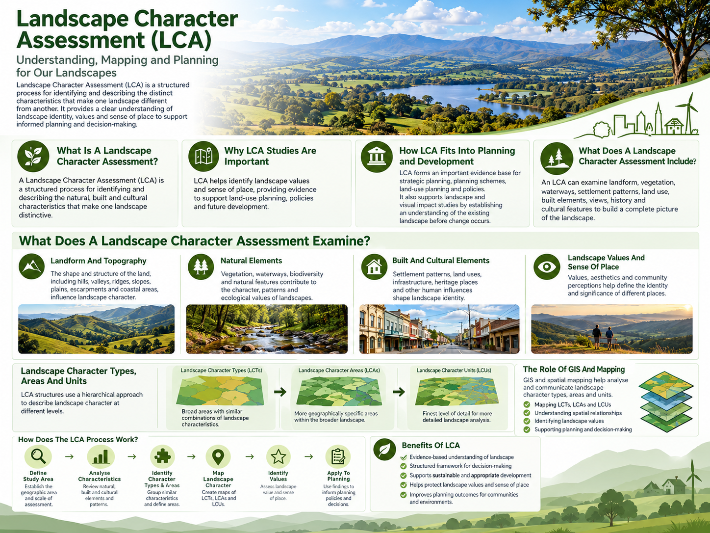
A landscape visual assessment examines how a proposed development may influence the surrounding landscape and how visible those changes will be from different viewpoints. A landscape visual assessment considers both the physical landscape and how people experience it. It evaluates existing landscape features, visual sensitivity, landscape character, and the likely effects of a proposed development. The assessment supports planning authorities by providing objective evidence about potential visual changes.
Common elements included
- Existing landscape character
- Natural and built environment
- Topography and landform
- Vegetation and screening
- Public viewpoints
- Visual simulations where required
- Assessment of landscape sensitivity
- Mitigation recommendations
What Is a Visual Amenity Assessment?
A visual amenity assessment focuses on how a development may affect the visual experience and enjoyment of people using a particular location. Rather than concentrating on the broader landscape, this assessment considers how changes influence the appearance, comfort, and quality of views from nearby public spaces, roads, parks, residential areas, and other sensitive locations. Visual amenity assessments are commonly requested where maintaining attractive views and neighbourhood character is an important planning objective.
Typical considerations include
- Existing visual quality
- Scenic views
- View obstruction
- Building scale
- Colour and materials
- Lighting impacts
- Public viewing locations
- Overall visual experience
Landscape Visual Assessment vs Visual Amenity Assessment
Although both assessments examine visual impacts, they answer different planning questions and are often used together on larger developments.
| Feature | Landscape Visual Assessment | Visual Amenity Assessment |
| Primary focus | Landscape character and visibility | Quality of public and private views |
| Main objective | Assess landscape change | Assess visual experience |
| Area covered | Regional and local landscape | Specific viewing locations |
| Typical users | Planning authorities, developers | Councils, communities, planners |
| Key considerations | Landscape character, visibility, sensitivity | Scenic quality, visual comfort, neighbourhood appearance |
| Often includes | Landscape mapping and visual simulations | Viewpoint analysis and visual quality review |
When Is Each Assessment Required?
Planning requirements vary depending on the project location, scale, and local planning policies. Some developments require only one assessment, while others benefit from both. Visual Planning + Design helps clients identify the most appropriate assessment based on project requirements and planning objectives.
Landscape assessments are commonly required for
- Renewable energy projects
- Major infrastructure
- Quarries
- Large residential developments
- Tourism developments
- Rural developments
- Industrial projects
Visual amenity assessments are commonly required for
- Urban developments
- Multi-storey buildings
- Residential subdivisions
- Commercial developments
- Public facilities
- Coastal developments
- Scenic route planning
How a Landscape Visual Impact Assessment Supports Planning
A landscape visual impact assessment provides structured evidence that helps decision-makers understand how proposed developments may alter the surrounding landscape. Rather than relying on opinion, the assessment uses recognised methodologies to identify visibility, landscape sensitivity, and the scale of change. This information allows planners to evaluate whether impacts are acceptable under planning policies.
Key benefits include
- Better planning decisions: Objective reporting gives councils and approval authorities reliable information during the assessment process.
- Early identification of issues: Potential visual concerns can be identified before construction begins, reducing costly design changes later.
- Improved project design: Developers can modify layouts, building locations, landscaping, and materials to reduce visual impacts.
- Greater community: understanding Clear maps, viewpoints, and visual simulations help explain how a proposal may appear once completed.
Why Visual Amenity Matters
Visual amenity influences how people experience their surroundings and contributes to the overall quality of places where they live, work, and visit. Even if a development has limited landscape impacts, it may still affect nearby residents through changes to important views, neighbourhood character, or scenic outlooks. Visual amenity assessments help planners balance development needs with community expectations by examining these local visual effects.
The Role of Landscape Planning Consultants
Experienced Landscape Planning Consultants help integrate environmental, planning, and visual considerations into development proposals from the early design stage. Their work goes beyond preparing reports. They analyse site conditions, interpret planning policies, coordinate visual studies, and recommend practical design improvements that reduce visual impacts.
They may assist with
- Site investigations
- Landscape character analysis
- Planning policy review
- Visual impact studies
- Viewpoint selection
- Photomontages
- Mitigation strategies
- Planning documentation
Methods Used During Visual Assessments
Professional assessments follow recognised methodologies to produce consistent, evidence-based findings suitable for planning applications. The exact process depends on the project, but most assessments include several key stages.
- Site inspection: Consultants visit the site to understand existing landscape conditions, surrounding land uses, vegetation, and important viewpoints.
- Desktop research: Planning schemes, aerial photography, mapping, environmental studies, and local planning policies are reviewed before fieldwork.
3.Visibility analysis: The assessment identifies where the proposed development is likely to be visible and who may experience those views.
- Photography and simulations: Photographs from representative viewpoints may be combined with accurate visual simulations to illustrate future conditions.
- Impact evaluation: The significance of visual changes is assessed by considering landscape sensitivity, viewing distance, project scale, and duration.
- Mitigation recommendations: Practical design improvements may include additional planting, building colour selection, reduced building height, or revised layouts.
Factors That Influence Visual Impact
Every site is different, so multiple environmental and design factors influence the final assessment.
Some of the most important considerations include:
- Existing vegetation
- Landform and elevation
- Building height
- Development scale
- Distance from viewpoints
- Scenic quality
- Existing land use
- Seasonal vegetation changes
- Road corridors
- Public viewing areas
Choosing the Right Assessment
Selecting the appropriate assessment depends on the nature of the proposal, planning requirements, and the surrounding environment. A rural wind farm, for example, is more likely to require detailed landscape analysis across a large area. An urban apartment development may place greater emphasis on visual amenity from neighbouring properties and public streets. Many larger developments require both studies because they provide complementary information rather than duplicate reporting. Seeking professional advice early in the planning process helps identify the most suitable assessment requirements before preparing an application.
Conclusion
Landscape and visual assessments each play an important role in responsible planning. While landscape assessments examine broader landscape character and visibility, visual amenity assessments focus on how people experience changes to their surroundings. Understanding these differences allows developers, planners, and approval authorities to prepare appropriate supporting documentation and make more informed planning decisions. Visual Planning + Design provides independent visual assessment services that help projects meet planning requirements while supporting thoughtful landscape outcomes. Contact us today to learn how our team can assist with landscape and visual assessment requirements for your next development project.