28
JuneWhat is a verified photomontage and why does it matter?
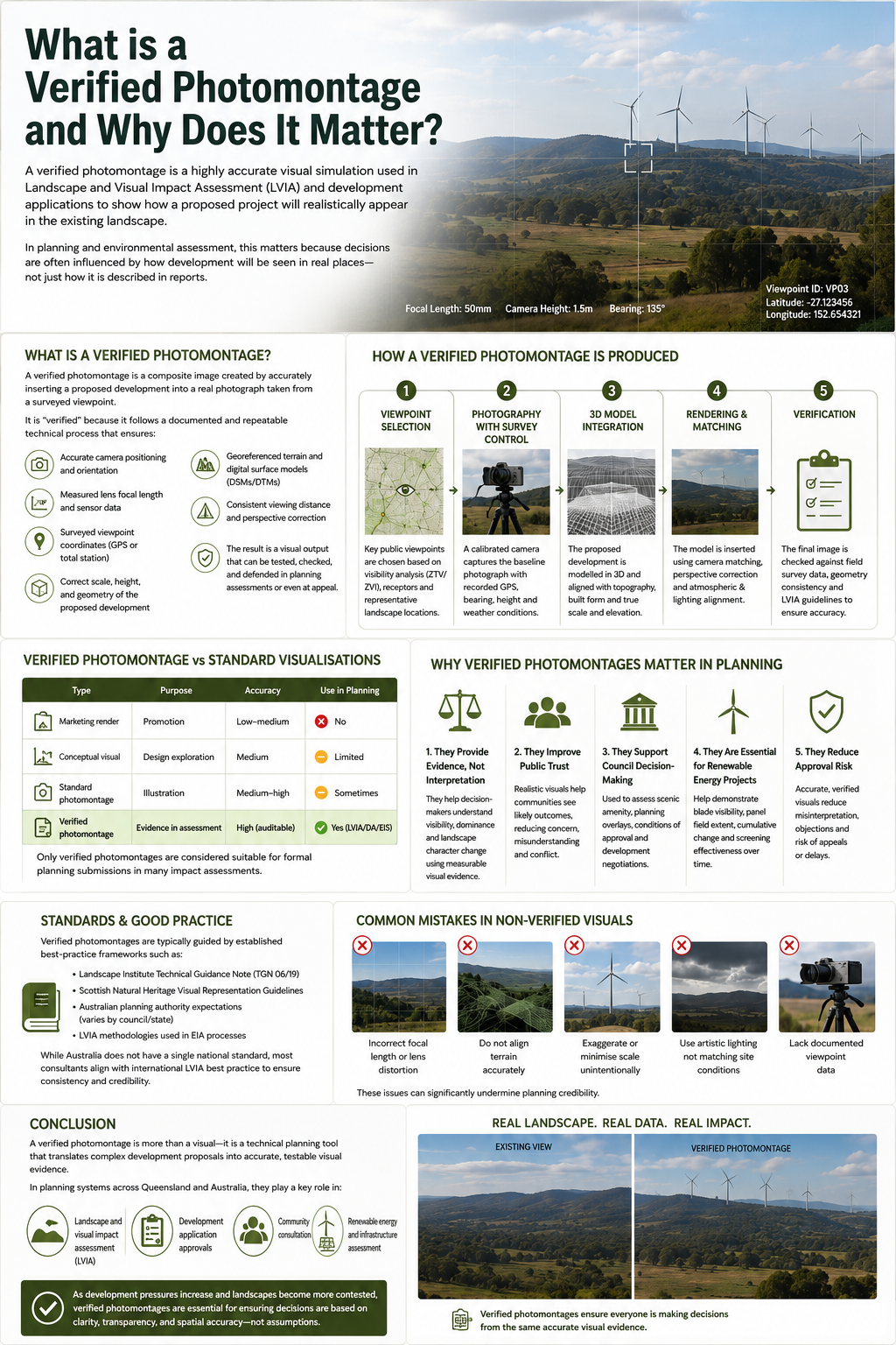
A verified photomontage is a highly accurate visual simulation used in Landscape and Visual Impact Assessment (LVIA) and development applications to show how a proposed project will realistically appear in the existing landscape.
Unlike standard architectural renders or marketing visuals, a verified photomontage is produced using strict technical methodologies so that planners, councils, and the public can trust it as an evidence-based representation of visual change.
In planning and environmental assessment, this matters because decisions are often influenced by how development will be seen in real places—not just how it is described in reports.
What is a Verified Photomontage?
A verified photomontage is a composite image created by accurately inserting a proposed development into a real photograph taken from a surveyed viewpoint.
It is “verified” because it follows a documented and repeatable technical process that ensures:
- Accurate camera positioning and orientation
- Measured lens focal length and sensor data
- Surveyed viewpoint coordinates (often GPS or total station)
- Correct scale, height, and geometry of the proposed development
- Georeferenced terrain and digital surface models (DSMs/DTMs)
- Consistent viewing distance and perspective correction
The result is a visual output that can be tested, checked, and defended in planning assessments or even at appeal.
How a Verified Photomontage is Produced
A proper verified photomontage typically follows a structured workflow:
1. Viewpoint Selection
Key public viewpoints are chosen based on:
- Visibility analysis (often supported by ZTV/ZVI mapping)
- Relevance to receptors (roads, homes, public spaces)
- Scenic or representative landscape locations
2. Photography with Survey Control
A calibrated camera is used to capture the baseline photograph:
- Fixed focal length lens (no zoom variation)
- Levelled tripod and measured height
- Recorded GPS coordinates and bearing
- Weather and visibility conditions documented
3. 3D Model Integration
The proposed development is modelled in 3D software and aligned with:
- Topographic terrain data
- Existing built form and vegetation structure
- True scale and elevation data
4. Rendering and Matching
The model is inserted into the photograph using:
- Camera matching (photomatching)
- Perspective correction
- Lighting and atmospheric alignment
5. Verification
The final image is checked against:
- Field survey data
- Geometry consistency
- Planning standards and LVIA guidelines
This ensures the image is not interpretive, but measurably accurate.
Verified Photomontage vs Standard Visualisations
It is important to distinguish verified photomontages from other types of visual outputs.
| Type | Purpose | Accuracy | Use in Planning |
|---|---|---|---|
| Marketing render | Promotion | Low–medium | No |
| Conceptual visual | Design exploration | Medium | Limited |
| Standard photomontage | Illustration | Medium–high | Sometimes |
| Verified photomontage | Evidence in assessment | High (auditable) | Yes (LVIA/DA/EIS) |
Only verified photomontages are considered suitable for formal planning submissions in many impact assessments.
Why Verified Photomontages Matter in Planning
Verified photomontages are critical because they support transparent, defensible decision-making in development assessment.
1. They Provide Evidence, Not Interpretation
Planners and decision-makers need to understand:
- How visible a development will be
- How dominant it may appear
- How it changes landscape character
A verified photomontage turns abstract design into measurable visual evidence.
2. They Improve Public Trust
Community concern about visual impacts is common in projects such as:
- Solar farms
- Wind farms
- Suburban expansion
- Infrastructure corridors
Verified imagery helps communities see realistic outcomes, reducing misunderstanding and conflict.
3. They Support Council Decision-Making
Local governments use verified photomontages to:
- Assess scenic amenity impacts
- Evaluate compliance with planning scheme overlays
- Support conditions of approval
- Inform development negotiations
They often sit alongside Landscape Character Assessment (LCA) and LVIA reports.
4. They Are Essential for Renewable Energy Projects
In large-scale renewable energy developments, visual impacts can extend over long distances.
Verified photomontages help demonstrate:
- Blade visibility in wind farms
- Panel field extent in solar farms
- Cumulative landscape change
- Screening effectiveness over time
5. They Reduce Approval Risk
Poorly represented visuals can lead to:
- Misinterpretation of scale
- Planning objections
- Legal challenges or appeals
A verified photomontage reduces uncertainty by ensuring all stakeholders are working from the same visual evidence base.
Standards and Good Practice
Verified photomontages are typically guided by established best-practice frameworks such as:
- Landscape Institute Technical Guidance Note (TGN 06/19)
- Scottish Natural Heritage Visual Representation Guidelines
- Australian planning authority expectations (varies by council/state)
- LVIA methodologies used in EIA processes
While Australia does not have a single national standard, most consultants align with international LVIA best practice to ensure consistency and credibility.
Common Mistakes in Non-Verified Visuals
Many visualisations submitted in development contexts fail because they:
- Use incorrect focal length or lens distortion
- Do not align terrain accurately
- Exaggerate or minimise scale unintentionally
- Use artistic lighting not matching site conditions
- Lack documented viewpoint data
These issues can significantly undermine planning credibility.
Conclusion
A verified photomontage is more than a visual—it is a technical planning tool that translates complex development proposals into accurate, testable visual evidence.
In planning systems across Queensland and Australia, they play a key role in:
- Landscape and visual impact assessment (LVIA)
- Development application approvals
- Community consultation
- Renewable energy and infrastructure assessment
As development pressures increase and landscapes become more contested, verified photomontages are essential for ensuring decisions are based on clarity, transparency, and spatial accuracy—not assumptions.